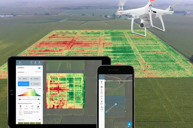
Modern mine drones are revolutionizing the way we approach mining operations, offering a safer, more efficient alternative to traditional methods. These drones are specifically designed to handle the unique challenges of both underground and surface mining environments. As drone technology continues to evolve, the possibilities for their application in the mining sector are virtually limitless. A mine drone is a specialized unmanned aerial vehicle (UAV) built to address specific needs within the mining industry, such as stockpile measurement, surveying, mapping, and inspections. These drones often come equipped with advanced sensors like LiDAR or ultrasonic devices for detailed inspections. One of the standout features of mine drones is their ability to fly without relying on GPS, which is often unavailable in mining environments. Adopted widely by the mining industry, drones have become indispensable tools for enhancing data collection, boosting safety, and cutting operational costs. Here are six key ways drones are being utilized in mining today: Volumetric measurement involves determining the amount of material remaining in stockpiles of overburden, ore, or other mining resources. Given the immense scale of these stockpiles, getting accurate volume reports manually is a daunting task. However, integrating mine drones simplifies this process significantly. These drones can be deployed quickly and affordably, delivering reliable volume data. Regular monitoring of stockpile variations not only cuts costs but also minimizes waste. Advanced volume measurement software processes drone data to create 3D models. Algorithms calculate the volume between the base layer and the surface, using either photos processed through photogrammetry or laser scans from LiDAR sensors. Mine drones can also track the amount of material removed from a specific area and estimate backfill requirements for stopes. Over time, these 3D models help in analyzing trends and changes. Challenges like crumbling rocks, gas leaks, dust explosions, and chemical byproducts pose serious risks to miners. Mine drones help mitigate these dangers by allowing remote inspections, thereby reducing the need for human presence in hazardous zones. In surface mining, drones continuously monitor stockpile stability, helping detect early warning signs of instability. This proactive approach ensures the safety of personnel while maintaining operational efficiency. In underground mining, drones like the Elios 3 can navigate dusty, wet, and rocky passages to identify blockages, fractures, and other geological features.
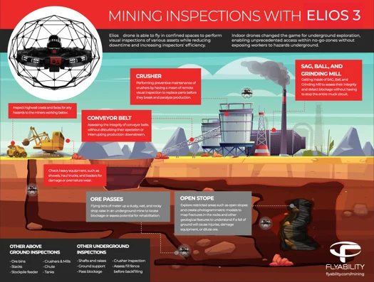
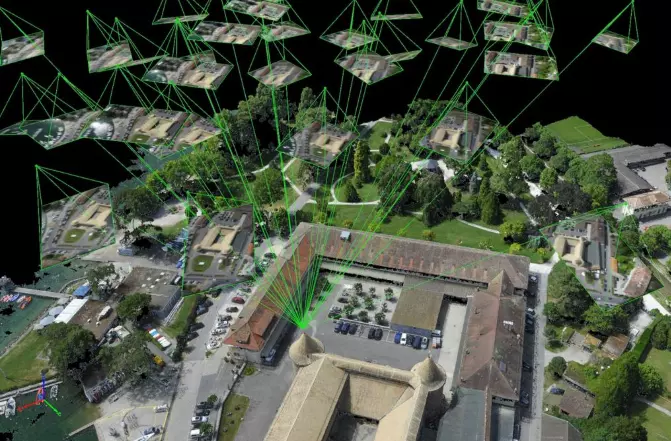
Data collected by mine drones is invaluable for creating 3D models that serve multiple purposes. Before drilling and blasting operations begin, these models act as historical records to evaluate past work. Updated models enable data-driven decisions regarding future operations, assess the effectiveness of certain techniques, and provide remote safety checks before entering potentially hazardous areas. A mine comprises numerous moving parts that require systematic analysis and adjustments to maximize efficiency and safety. Mine drones excel in several critical areas: Haulage Road Design: These roads transport mining materials from the worksite. Constant assessment of road conditions is essential due to heavy traffic and equipment. This data also helps determine whether infrastructure improvements are necessary. Equipment Inspections: Regular visual inspections of conveyor belts, crushers, grinding mills, and other vital components are crucial for reducing operating expenses and ensuring worker safety. Remote inspections via drones are cost-effective and safe tools for preventive maintenance. Worksite Security: Security drones are gaining popularity due to their rapid deployment capabilities and ability to cover large areas quickly. The hazardous conditions at quarries, aggregate sites, and underground mines make drones ideal for protecting investments. Having an aerial view is also beneficial when coordinating with emergency services. Environmental Monitoring: Mine drones are powerful tools for minimizing environmental impacts. For instance, tailing dams at worksites contain hazardous chemicals. Monitoring their stability prevents leaks or runoff from the site. Developing mining operations is traditionally costly and perilous. Historically, teams of miners had to explore unknown conditions to conduct stability analyses, surface mapping, ventilation modeling, and detect hazardous gases. Instead of sending people into inaccessible areas, drones can navigate tight spaces more safely and efficiently than humans ever could. This is especially useful for investigating abandoned sections of a mine. Drone mapping old workings keeps people safe while providing critical data. In underground mining, the Elios 3 stands out as the only drone capable of handling confined spaces with poor visibility, air quality, and signal disruptions. Drone inspections are employed in on-site mining processing plants to assess machinery without halting operations, ensuring profitability. Examples of drone applications in processing plants include: As drone technology advances, the benefits of UAVs in mining continue to grow. Embracing mine drones opens up new possibilities, enhancing safety, reducing costs, and boosting efficiency. Key advantages include: Watch the Elios inspect and map an obstructed ore pass:  Among the many capable drones available, few match the functionality, durability, and beyond-line-of-sight transmission capabilities of Flyability’s Elios 3. The Elios 3 is engineered to keep humans safe while gathering data in previously inaccessible areas. Its unique spherical cage protects against collisions, aiding pilots navigating dangerous, dark, and dusty locations. The dual thermal and 4K camera sensor, along with a 10K lumen dust-proof lighting system, enables the Elios 3 to collect all necessary visual data. Oblique lighting highlights textures and defects, making it easier to navigate mine shafts. With comprehensive training, easy maintenance, and a dedicated support team, the Elios 3 is the best mine drone on the market. Flyability Elios 3 Specs / Features: The WingtraOne GEN II’s fixed-wing design offers unparalleled flying time, performance, and versatility. Mapping mining operations has never been more efficient, with a flight speed of 16 m/s (36 mph) and 59 minutes of flight time. The 42-megapixel camera captures stunning and precise details. In just one flight, the Wingtra can cover an impressive 272 acres. Its vertical takeoff and landing (VTOL) system allows operation in any location. The onboard high-precision PPK GNSS receiver requires only three checkpoints to verify maps, eliminating the need for ground control points. WingtraONE GEN II Specs / Features: Camera Sensor: 42 megapixel Sony sensor with a full-frame sensor and low distortion lens. Sensing Capabilities: Compatible with various Sony and MicaSense sensors for any job. Flight Time: 59 minutes Flight Speed: 16 m/s (36 mph) Transmission System: Direct line-of-sight up to 10 km (6 miles) of range. The eBeeX is an incredibly robust drone that operates autonomously with minimal intervention. Simply program the flight path and launch the drone. The ultralight 3.6-pound frame allows it to cover an astonishing 1200 acres per flight. With interchangeable cameras, including aerial RGB, thermal, and multispectral options, the eBeeX is versatile enough for any task. The intuitive eMotion flight planning software is user-friendly for all skill levels. It includes mission planning modes for various applications and the ability to manage multiple drones simultaneously. The 3D environment simplifies planning, simulation, and operation, leading to improved data quality. SenseFly eBeeX Specs / Features: Camera Sensor: Choose from 9 sensors, including aerial RGB, thermal, and multispectral imagery Sensing Capabilities: Compatible with various SenseFly and MicaSense sensors for any job Flight Time: 90 minutes Flight Speed: 30 m/s (68 mph) Transmission System: Flight range of 37 km (23 miles). When it comes to outdoor mining drones, it’s hard to beat the DJI Phantom 4 RTK. The 1-inch, 20-megapixel CMOS sensor features a mechanical shutter essential for accurate mapping applications. DJI’s GS RTK app and smart remote controller streamline surveying missions with centralized control. The built-in OcuSync transmission system offers a range of 7 km (4.3 miles), making it ideal for medium-sized mine sites. The RTK module works with the D-RTK 2 Mobile Station to ensure centimeter-level accuracy in any environment. DJI Phantom 4 RTK Specs / Features: Camera Sensor: 20 megapixels with 4K video resolution Flight Time: 30 minutes Flight Speed: 13 m/s (31 mph) in P-Mode / 16 m/s (36 mph) in A-Mode Transmission System: DJI OcuSync DJI Phantom 4 RTK DroneDeploy’s mapping software for mining and quarries uses data to boost efficiency and accuracy in inspections, stockpile management, and other aspects of mining while keeping the mine team safe. Top Features: Stockpile Inventory Management Mine Planning and Excavation Safety and Compliance Centralized Operations Management Pix4D’s drone mapping and 3D modeling software for mines reduces risks and boosts profitability through image-based solutions. Top Features: Forecast geotechnical hazards Accurate and automatic stockpile volume calculation Asset lifecycle management Generate high-resolution interactive 3D maps Propeller’s drone software captures high-accuracy data to generate measurable 3D models accessible to the entire team. Top Features: Quick and frequent drone surveys Complete documentation of project lifecycle Simplified inventory management Collaboration and communication Skycatch’s software automates aerial data capture, processing, visualization, and analysis. Onboarding, training, and ongoing support are also provided. Top Features: Fastest time-to-data in the market Eliminates GCPs for safer data capture Proven 5 cm accuracy across all axes Process offline in the field or in the cloud Precise, high-fidelity 3D models of vertical surfaces Skycatch software Application: High-Altitude Underground Mining Inspection Mission: Demonstrate the ability of the Elios 2 to cut costs and improve safety in a high-altitude oxygen-depleted mine environment. The mine is located in Campamento Minero, approximately three miles above sea level. Results: The Volcan team conducted 40 flights with the Elios 2 inspecting chimneys, ore passes, ventilation tunnels, and stopes. 3D maps of the various flights were created using Pix4D mapping software. All planned inspections were successful, meeting all expectations. Mine Drone Significance: The Elios 2 was able to operate where no other drone can. Many mines are located in high-altitude locations where regular drone use is not feasible. By using a drone to navigate the mine, miners can let the Elios 2 do the dirty work while saving time and money. [Read the full case study here: Testing the Elios 2 at a High Altitude Mine Located in the Andes Mountains] Application: Mine / Quarry Monitoring and Operational Planning Mission: Reduce operating expenses of terrestrial and manned airplane surveys by integrating a fixed-wing mine drone platform into surveying operations. Quadcopter drones are not efficient for larger mines. Results: The Jellinbah Group found that utilizing the WingtraOne drone resulted in a significant decline in operational expenses and time. The fixed-wing platform also alleviated the inefficiencies of quadcopters that the company had tested previously. The ROI is immediately noticeable as Jellinbah can now conduct on-demand surveys compared to the time-consuming logistics of manned surveying. Mine Drone Significance: Large mining sites are no longer limited to multirotor drones that are inefficient and impractical. The vertical takeoff and landing feature is also a game-changer and allows surveys to be conducted anywhere. Application: Quarry Monitoring and Operational Planning Mission: Survey the largest limestone quarry in a day. The quarry measures a whopping 13.7 km2, and it usually takes two months to survey.  Results: The quarry was split into three large segments; upper, middle, and lower. Four drone pilots were divided into two teams to cover the site efficiently. The team decided to use senseFly's eBeeX fixed-wing drone. The eBeeX's ability to fly for longer durations made it the perfect choice. Within a few hours, the drone’s took over 6,000 high-resolution images that were converted into orthomosaic images and 3D models. Mine Drone Significance: Surveying a site of this size used to take up to 2 months. Not only does that cause delays, but it also increases the risks for surveyors. The benefit of using mine drones is quick turnaround time, resulting in a safer and more cost-effective operation. Application: Quarry Drilling and Blasting Mission: To identify how a customized drone solution for mining can deliver the safest, controlled, and cost-efficient execution of a scheduled blast operation in a quarry mine. Results: The customized DJI Matrice 300 RTK drone and Zenmuse H20t cameras functioned well regarding control and operational decision-making. Here are some areas the drone excelled in: Checking for compliance with minimum withdrawal distances Correcting the locations of lookouts. Replacement of the inspection vehicle bypass Observation of blind spots Overall survey and recording of mass explosion Mine Drone Significance: The purpose of using drones in mining is to combine miners' knowledge with the drone's digital intelligence. An operation becomes safer and less expensive over time by having actionable data. Application: Stockpile Volumetry Mission: Improve the accuracy of volumetric stockpile measurements to increase safety and reduce expenses for Granite Construction. Results: Using DroneDeploy, the company achieved accuracy comparable to traditional methods in a fraction of the time. For this site, all volume calculations were within 1% of alternatives. Mine Drone Significance: Using aerial volumetric software is faster, safer, and half the cost of traditional ground-based stockpile calculations. Clothing Folding Packing Machine Clothing Folding Packing Machine is designed mostly for small, medium and larger sized clothing workshops, laundry, garment manufacturing, and more other applicable textile areas with more comprehensive and flexible function. Garment Folding Equipment,Trousers Folding Machine,Shirt Folding Machine,T Shirt Folding Machine SHENZHEN LINGCHUANG ZHUOYUE TECHNOLOGY CO., LTD , https://www.lcautosz.comSix Ways Mine Drones Are Transforming Mining Operations
What Exactly Is a Mine Drone?
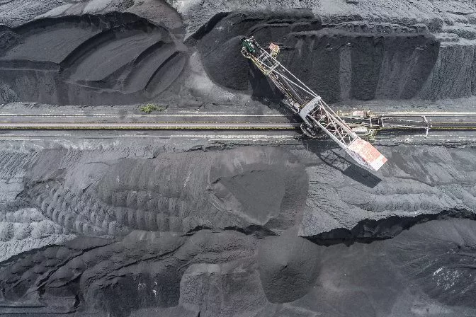 Aerial drone footage of a surface coal mine
1. Volumetric Monitoring
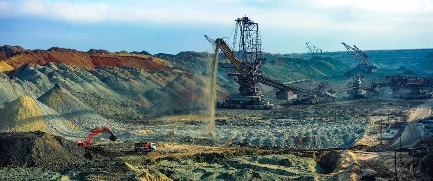 Processing overburden into stockpiles
2. Hazard Identification
3. Drilling and Blasting Assessment
 Drilling holes for explosives
4. Mine Monitoring and Planning
5. Mine Development and Exploration
6. Processing Plant Inspections
The Advantages of Using Drones in Mining
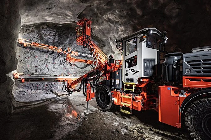
The Best Indoor Mine Drone on the Market
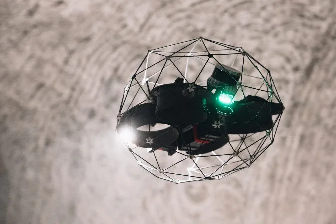 Elios 3
Best Fixed-Wing Outdoor Mine Drones on the Market
WingtraOne GEN II
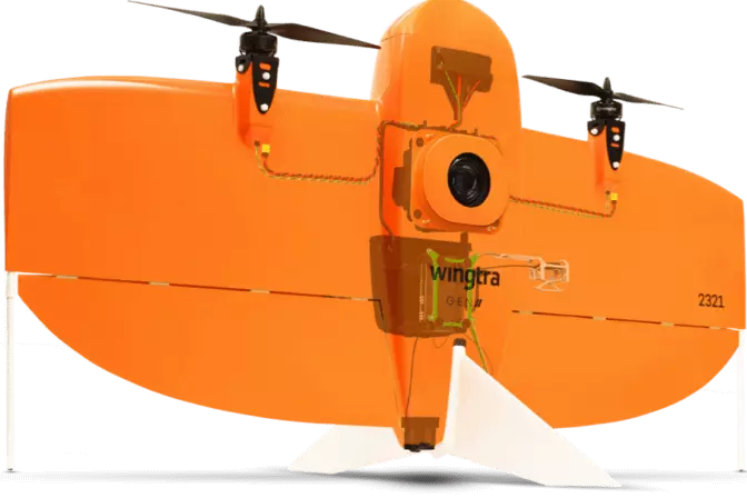 WingtraOne Gen II
SenseFly eBeeX
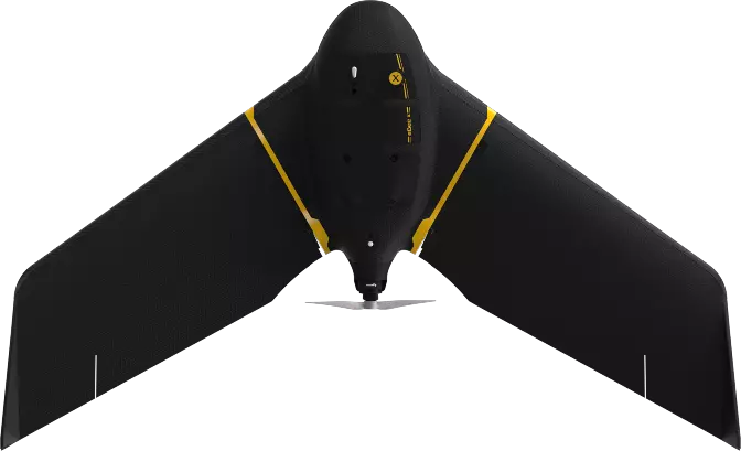 SenseFly eBeeX
Best Multicopter Outdoor Mine Drone on the Market
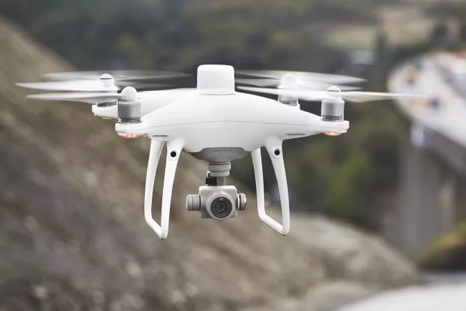
DJI Phantom 4 RTK
Best Mine Drone Software
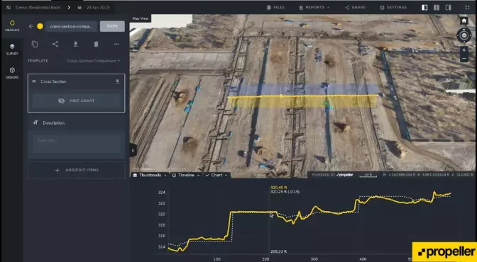
DroneDeploy
 DroneDeploy software | Medium
Pix4D
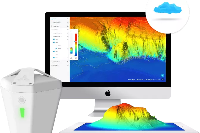
 Pix4D software
Propeller
 Propeller software
Skycatch
Mining Drone Case Studies
Flyability Elios 2 — Inspection
Wingtra— Survey
SenseFly— Survey
DJI— Survey
DroneDeploy— Stockpile Measurement
The average capacity is around 500-700 pieces per hour, which is far fast than Simple Clothing Folding Machine.
Clothing Folding Packing Machine contains many systems like Folding Packing With Sealing , Folding Packing With Stacking, Folding Packing With Feeding and Folding Packing With Labeling.
This type is well received for more kinds clothes packaging. It`s advanced version compared with Simple Clothing Folding Machine